30 April 2007

Weekly MilCom Recap; 23-29 April 2007

Frequencies

Hunter AAF
133.550 - Tower
279.575 - Tower
126.200 - Base Ops
32.350 - 3/3 AVN Ops
38.150 - B-169 AVN Ops
242.400 - B-169 AVN air-to-air
406.1625 - Tower/Base Ops
406.7625 - POL
415.1625 - Trans Alert

Savannah IAP
119.100 - Tower
257.800 - Tower
120.400 - Approach/Departure
380.025 - Approach/Departure
125.300 - Approach/Departure
387.100 - Approach/Departure
118.400 - Approach/Departure
307.225 - Approach/Departure
225.750 - 165th Airlift Wing Command Post
225.050 - 165th AW air-to-air
138.050 - 165th AW air-to-air
237.000 - Savannah CRTC Ops

Fort Stewart/Wright AAF
127.350 - Marne Radio
279.625 - Marne Radio
126.250 - Wright AAF Tower
269.275 - Wright AAF Tower

MCAS Beaufort
119.050 - Tower
340.200 - Tower
118.450 - Approach/Departure
301.200 - Approach/Departure
361.800 - VMFA-115 Base
339.500 - VMFA-115 Tac 1
320.200 - VMFA-115 Tac 2
253.100 - VMFA-122 Base
283.400 - VMFA-122 Tac 1
354.325 - VMFA-122 Tac 2
313.800 - VMFA-251 Base
327.475 - VMFA-251 Tac 2
228.200 - VMFA-312 Base
301.950 - VMFA-312 Tac 1
320.300 - VMFA-312 Tac 2
310.200 - VMFA(AW)-533 Base
289.275 - VMFA(AW)-533 Tac 1
354.400 - VFA-86 Base
308.925 - VFA-86 Tac 1
363.825 - VFA-86 Tac 2

Shaw AFB
381.300 - Shaw Command Post
342.500 - Shaw PMSV
311.200 - 55th Fighter Squadron Ops
141.900 - 55th FS V8
273.700 - 77th Fighter Squadron Ops
143.800 - 77th FS V8
141.750 - 77th FS V9
140.375 - 77th FS V10

McEntire ANGB
298.300 - 169th Fighter Wing Ops
125.125 - 169th FW V1
140.125 -169th FW V17
141.925 -169th FW V18
141.825 - 169th FW V19

Jacksonville IAP
251.250 - 125th Fighter Wing Ops/Maintenance
273.900 - 125th Fighter Wing SOF
234.800 - 125th FW Aux 6
253.700 - 125th FW Aux 7

Ranges/MOAs
119.225 - Townsend Range Control
228.400 - Townsend Range Control
252.900 - Townsend Range Control
343.750 - Bulldog MOA
264.700 - Poinsett Range
354.300 - Poinsett Range; BEEFEATER ECM Range
269.000 - Gamecock MOA

Sealord (SC/GA/FL offshore areas)
120.950 - North Primary
284.500 - North Primary
267.500 - South Primary
376.900 - W-157 Discrete
385.300 - W-157 Discrete
350.675 - N. TACTS Range Discrete
381.875 - N. TACTS Range Discrete

Doubleshot (SC offshore area)
127.725 - Primary
279.725 - Primary
258.400 - Discrete
381.350 - Discrete

NORAD/AWACS Discretes
364.200 - AICC
234.600
316.300
320.600

Miscellaneous
134.100 - PALMETTO OPS (Charleston AFB)
228.225 - ANGEL OPS (23rd Wing, Moody AFB)
258.900 - unknown air-to-air, possibly VMFT-401
264.675 - unknown air-to-air
292.100 - "AR Prime" for VMM-263
333.100 - unknown air-to-air, probably 4th FW
349.400 - PALMETTO OPS (Charleston AFB)
362.475 - unknown, possible C-130 or P-3

Air Traffic Control
256.900 - Jax Center, unknown area
277.400 - Jax Center Brunswick Low
282.200 - Jax Center Jekyll Low
282.300 - Jax Center Alma High
285.650 - Jax Center Statesboro High
290.400 - Jax Center Waycross Low
319.200 - Jax Center Aiken High
322.500 - Jax Center Savannah Low
351.700 - Jax Center Summerville High
363.200 - Jax Center Allendale Low
379.100 - Jax Center Charleston Low

306.925 - Charleston App/Dep

323.000 - Atlanta Center Macon

255.400 - FSS


Callsigns
Hunter AAF
ARMY - Miscellaneous Army Aircraft
GUARD - Miscellaneous Nationa Guard Aircraft
TESTHOOK - CH-47, OLR
SUNNY - RC-12N, 224 MI Bn
COAST GUARD - Miscellaneous Coast Guard Aircraft
REACH - Airlift Missions
EVAC - Medevac Missions
NAVY HR ### - SH-60, HSL-48
Savannah IAP
DAWG - C-130, 165th AW
NOAA - Misc NOAA aircraft
HERK - C-130, unknown unit
NAVY HK ### - SH-60, HSL-40
HAWK - A-10, 131st FS, TDY for Turkey Shoot
YANKEE - A-10, 118th FS, TDY for Turkey Shoot
SHARK - A-10, 23rd Wing
MCAS Beaufort
BLADE - F/A-18A+, VMFA-115
NIKEL - F/A-18C, VMFA-122
TBOLT - F/A-18C, VMFA-251
CHECK - F/A-18A+, VMFA-312
HAWK - F/A-18D, VMFA(AW)-533
WINDER - F/A-18C, VFA-86
SNIPER - F-5, VMFT-401
Shaw AFB
GOLD - KC-135, Coronet Mission
BRAG - F-16CJ, 55th FS
BLUTO - F-16CJ, 77th FS
PEAK - F-16CJ, 77th FS
ROULETTE - F-16CJ, 77th FS
McEntire ANGB
MACE - F-16CJ, 169th FW
VIPER - F-16CJ, 169th FW
DEMON - F-16CJ, 169th FW
Jacksonville IAP
FANG - F-15A, 125th FW
SNAKE - F-15A, 125th FW
Miscellaneous
ADLER - F-15E, 4th FW
BANZAI - A-10, 23rd Wing
BANDSAW - E-3 AWACS, 964th ACCS
BOEING - C-17, Depot flight
DRAGNET - E-3 AWACS, 966th ACCS
FUZZY - KC-135, 107th ARW
GATES - F-15E, 4th FW
LANCER - F-15E, 333rd FW
NAVY LL - P-3C, VP-30
PITMAN - F-16CJ, 20th FW
RHET - KC-135, 19th ARG
ROMAN - F/A-18, VFA-106
THUNDER - MV-22, VMM-263
SCALP - B-52, 917 BW
SENTRY - E-3 flight deck
VIDAR - S-3B, VS-22
Mac McCormick, KF4LMT

27 April 2007

US Fish and Wildlife Repeater System?

I spent the afternoon doing some searches on various bands and found what sounds like a US Fish and Wildlife P25 VHF linked repeater system. There were mentions of a Skidaway site (near Savannah), a Blackbeard site (Blackbeard Island National Wildlife Refuge), and a Eulonia site (McIntosh County near Blackbeard Island NWR).

169.825
171.650
172.450 - Skidaway Site? (very strong in Savannah)
172.650

I am fairly certain that none of the above frequencies are repeater inputs. All stations heard on the frequencies were of equal signal quality/strength. The same traffic was multicast on all 4 frequencies. 172.450 was very strong here in Savannah and should be the Skidaway site mentioned above. The other three were practically equal in signal strength, so it is difficult to tell where they might be. Apparently it is a new system, conversations I monitored indicated that the system is not fully functional yet.

Mac McCormick, KF4LMT
kf4lmt@comcast.net

Sweat Farm Road Fire News - 27 April 2007

According to the Georgia Forestry Commission's Wildfire Situation Report, the Sweat Farm Road Fire in Waycross is impinging on US Highway 1. Some embers crossed the highway yesterday, but as of 0200 last night, it was 100 yards east of the highway. The fire has burned 61,109 acres, has cost approximately $3.1 million, and is 50% contained. They still estimate it will be contained on 30 April 2007. 464 personnel are committed to fighting the fire along with a Bell 407 helicopter, a UH-1 helicopter, 2 CH-47 helicopters, and P-3 Orion tankers. Although structures were protected, evacuations in some areas, including Astoria were necessary (according to media reports). In particular danger, according to the National Incident Information Center, were the Incident Command Post, the city of Astoria, the Okefenokee Swamp Park, a State Park, and the Lions Camp for the Blind.

Additionally, the Kneeknocker Fire in Brantley County rekindled, forcing some evacuations.

Frequency-wise, I really don't have anything to offer because I am too far away from the area to be able to pull anything in. I can suggest 38.150, 139.400 (AM), and 242.400 for the CH-47 Chinooks involved in the firefighting efforts. I have heard these frequencies in use as they have departed from and arrived from Hunter AAF for fire duties.

The National Weather Service forecasts for the Waycross area show a slight chance of rain today and continued dry weather for the coming days. The fire danger rating for the Waycross area remains at Very High to Extreme.

I realize that this is a radio related blog and I usually don't bring religion into it, but if you are a religious person, please pray for the folks in the area of these fires. Keep them in your thoughts and pray for rain to help out all of the fire, forestry, law enforcement, and other emergency personnel that are putting in such long hours fighting these fires and trying to protect the communities around them.

Mac McCormick, KF4LMT
kf4lmt@comcast.net

26 April 2007

2007 Townsend Range Turkey Shoot Report

The 2007 Townsend Turkey Shoot offered some good monitoring this morning. I was able to catch two thirds of the competition live from home and caught the rest on a recording. As a result some of the final competitors are either unidentified or have no air-to-air frequency listing. If anyone is able to identify RAZOR 11 flight or CLAW 11 that among the final competitors, please let me know. I have some guesses, but without air-to-air frequencies or aircraft type IDs, I've got nothing solid.

228.400 was used for initial check in with Townsend Range and to pass the 9-line target descriptions. Once the flights were cleared into the range for their bombing and strafing passes, the were pushed to 252.900. 380.025, Savannah Approach control and 282.200, Jacksonville Center Jekyll Low sector were for entry into the area. Here are the flights I logged:

ARMY 15280/95146 - (AH-64D, 3-3 AVN)
WINDER 11-14 - (F/A-18C, VFA-86); 308.925 Tac 1
YANKEE 01-04 - (A-10, 118 FS); 138.550, 140.200 a2a
HAWK 81 - (F/A-18D, VMFA-533)
GATES 31-34 - (F-15E, 4 FW); 300.725 a2a
ADLER 21-24 - (F-15E, 4 FW); 301.125 a2a
HAWK 11-14 - (A-10, 131 FS); 139.900, 143.825 a2a
SHARK 11/12 - (A-10, 23 Wing)
RAZOR 11-14 - (unknown)
MACE 11-14 - (F-16CJ, 169 FW)
CLAW 11 - (unknown)

An interesting visitor prior to the beginning of the competition was N6320T, a P-51D Mustang. He apparently flew a demonstration flight prior to the arrival of the AH-64s.

According to a report from the ScanSavannah email group, this year's winners were the YANKEEs from the Connecticut Air National Guard. For those that have followed the Turkey Shoot for any length of time, this does not come as a suprise. They have won several times previously and have always placed high in the standings.

Mac McCormick, KF4LMT
kf4lmt@comcast.net

24 April 2007

Townsend Range Turkey Shoot Participant Update

More flights worked Townsend Range throughout the day getting in range familiarization flights for the Turkey Shoot. A-10s from the 118th Fighter Squadron, CT ANG and the 131st Fighter Squadron, MA ANG did familiarization flights on the range and landed at Savannah IAP afterwards. Here is an updated Turkey Shoot frequency list:

228.400 - Townsend Range Control
119.225 - Townsend Range Control
252.900 - Townsend Range Control

282.200 - Jax Center Jekyll
277.400 - Jax Center Brunswick
380.025 - Savannah Approach/Departure
120.400 - Savannah Approach/Departure
257.800 - Savannah IAP Tower
119.100 - Savannah IAP Tower
237.000 - Savannah CRTC Ops

140.200 - 118 FS air-to-air (A-10)
139.900 - 131 FS air-to-air (A-10)
141.675 - 131 FS air-to-air (A-10)
143.825 - 131 FS air-to-air (A-10)
140.150 - 23 Wing air-to-air (A-10)

Mac McCormick, KF4LMT
kf4lmt@comcast.net

Learning the BC-396

I played around with the programming of the BC-396 several times today and used it to help with monitoring the military, Coast Guard, and public safety. One thing I learned is that the stock antenna is acceptable for public safety monitoring but it isn't very good for military monitoring (surprise!) or aviation monitoring. As a result, I've decided to go ahead and order an RH-77C antenna with SMA connector this coming payday. I've been using my BNC RH-77C with the BC-396's supplied BNC-SMA adapter with success.

I have been playing around with the content and organizations of the systems and with the groupings of the systems by quick keys. The problem hasn't been grasping the idea of systems, groups, and quick keys. All of that makes sense. The problem has been remembering what quick keys are assigned to what systems. I keep on coming up with better ways to organize frequencies within the systems and groups. Likewise, new ways of assigning the groups to quick keys keep coming to mind. I would guess that it will just be a trial and error process until I decide how I like them organized. Unlike the banks of older scanners, the dynamic memory of the 396 offers up a multitude of possibilities.

I took the BC-396 with me on my walk to the barber shop this morning. I really noticed the small size of the radio. Compared to carrying the BC-250 or older handhelds on my belt, the BC-396 was like a feather. This radio will be great for event monitoring. It isn't as heavy as other radios and it takes up less space on your side (I'm already wide enough without adding a few more inches...). The ability to power it from common AA batteries and the Close Call function also add to it's utility as an event scanner. I really look forward to being able to take it to a race at Oglethorpe Speedway or some other event and putting it to the test.

Mac McCormick, KF4LMT
kf4lmt@comcast.net

Townsend Range Turkey Shoot

Townsend Range's annual Turkey Shoot will take place tomorrow, April 25, at the range in McIntosh County, GA. Aircraft from various units will take part in a competition of bombing and aerial gunnery accuracy. Based on what I've heard recently while monitoring Townsend Range, participants should come from F/A-18s from MCAS Beaufort, F-16s from the 169th Fighter Wing from South Carolina, A-10s from the 23rd Wing at Moody and Pope AFBs, and AH-64s from 3-3 AVN at Hunter AAF. There will likely be other participants as well.

If you are interested in monitoring the Turkey Shoot, here are some range and area ATC frequencies to keep an ear on:

228.400 - Townsend Range Control
119.225 - Townsend Range Control
252.900 - Townsend Range Control

282.200 - Jax Center Jekyll
277.400 - Jax Center Brunswick
380.025 - Savannah Approach/Departure
120.400 - Savannah Approach/Departure

Mac McCormick, KF4LMT
kf4lmt@comcast.net

Sweat Farm Road Fire News

According to the US Forestry Service National Incident Information Center, the Sweat Farm Road Fire is 45% contained as of Monday, April 23. 329 residences, FAA radio towers, and commercial radio towers are still endangered by the fire. 55,619 acres, 18 residences and 5 outbuildings have burned so far. 359 personnel are involved in firefighting efforts and the estimated date of containment is April 30.
Source: http://www.fs.fed.us/news/fire/mreport.shtml

The Georgia Forestry Commission estimates the cost of firefighting efforts so far at $1.7 million with an end cost of $10.7 million. Georgia Forestry reports that they made great progress on the fire yesterday, putting in miles of fire breaks on all sides of the fire. 23 miles of containment line are still needed, however and they also give an estimated containment date of April 30.
Source: http://www.gfc.state.ga.us/GFCNews/WildfireSituationReport.cfm

23 April 2007

The BC-396 Arrives

Last week I ordered a Uniden BC-396. Over the weekend, I created a programming file using Butel's ARC 396 software so that I would have something ready to put in the radio once it arrived. This afternoon the radio arrived. The first thing I thought when I pulled the radio out of the box was "this thing is tiny!" It is amazing that a scanner this capable comes in a package this small. It is, at most, 2/3 the size of my trusty old BC-250 (see photo below, BC-250 on the left and BC-396 on the right).


If you are thinking about programming this radio by hand, DON'T. This is a radio best programmed by computer. It would probably take you the better part of a month to program it by hand, wearing down several finger tips in the process.


After putting some AA batteries in (try that with earlier Uniden trunktracking scanners), I uploaded the ARC 396 program and started scanning. I immediately noticed that unlike the 250, the 396 does not display both talkgroup/frequency and the alphanumeric tag, just the alphanumeric tag. This is a minor annoyance, but a workaround using system/group arrangement and alphanumeric tags remedied the situation. In the process, I also learned a great deal about the radio.


Amazingly, after programming in all of what I had in the 250 plus a few new conventional and trunking systems into the 396, I am only utilizing approximately 20% of it's memory.


I tried to get a general feeling for the radio today, I'll be seeing what it can do on the various bands over the next few days and I'll post another report on the performance.


Mac McCormick, KF4LMT
kf4lmt@comcast.net

Sweat Farm Road Fire News

From the US Forestry National Incident Information Center from April 22:
"Sweat Farm Road is located 10 miles west of Waycross. Yesterday, the wind-driven fire spread to 55,619 acres. Most of the acreage increase was due to burnout operations. A Type 2 Incident Management Team (Floyd) is assigned along with some members of the Atlanta-based National Incident Management Organization (NIMO). 18 residences and five outbuildings have been destroyed and there remains a threat to 320 residences. Good progress was made yesterday as winds were lighter slowing the rate of spread. Smoke continues to affect highway traffic."

"Big Turnaround is located 10 miles west of Waycross. Access to the area is limited. The fire is burning in southern rough and pine plantations. There is a low threat to Okfenokee National Wildlife Refuge. Some torching and crowning were observed."


From the Georgia Forestry Commission Wildfire Situation Report from April 22:
Acres: 55,619
Cost to Date: 1.4 million
Containment: 39%
Committed Resources: about 500 personnel (will know tomorrow from Plans)
Estimated Containment Date: 4/27/07

Today's Events:
Rangers improved firebreaks along northern and western portions of fire nearest to Waycross. Much head way was made in strengthening the breaks and mop up has begun in order to cool hot spots. Because of these efforts by the combined effort of the GFC Rangers and Local firefighters Waycross is much safer today.

Along the southern portion of the fire was another story all together. The morning provided much need relief due to subdued weather condition, but as afternoon drew closer fire conditions changed from great to horrible. Lower humidity and increase variable winds provided renewed energy to the sleeping giant. A couple of spot fires, along Davis and Glenmore Rd., provided extra work for crews today. Flame lengths were measured at 100ft. Nearby units were able to contain fire and are moping up. GFC Type 2 Team used air tankers from nearby Lake City, Florida to cool fire and contain it. Fire Operations Chief said, "The fire just want quit".

Tomorrow's Plans:
The team will continue to strengthen lines and continue mop up in contained areas. We will be shifting resources from Divisions A,B,C, and H to Divisions I, J, and K. The reason for shifting these resources, are to bring fresh new rangers and larger equipment to the hottest areas. Burn-out operations will continue tomorrow as well to continue creating black line between the Swamp Road and the head fire.

Weather is looking pretty consistent throughout the upcoming week with a very slight chance of rain on Friday.

22 April 2007

Frequencies for CH-47s Fighting the Sweat Farm Road Fire

I finally caught some of the CH-47s going to and from Waycross to assist in firefighting efforts. GUARD 262 and 249 were today's aircraft. Both aircraft are from B-169 AVN of the Georgia Air National Guard at Hunter Army Airfield in Savannah. Here are the frequencies they used today:

38.150 - HURRICANE OPS
139.400 - HURRICANE OPS
242.400 - Air to Air

Mac McCormick, KF4LMT
kf4lmt@comcast.net

Miscellaneous Sweat Farm Road Fire News

From the FEMA website:

A large wild fire south-southwest of Waycross, GA covers about 20,000 acres and is uncontained. There are 25 fire tractors, two National Guard Chinook helicopters, an air tanker from Lake City and two other helicopters from the Forestry Service. They are still unable to get control of the fire. This fire is threatening an unknown number of homes and businesses within the city limits of Waycross, GA. The Forestry Service is looking at various contingency plans. The Okefenokee Swamp Park has been closed and evacuated. All animals that could be evacuated have been sheltered.Other new fires have added to the threats. There is a separate fire northwest of Nahunta, GA which is a 2,000 acre fire; a fire near Nashville GA is over 300 acres; and another 500 acre fire in Fargo, which is near the Okefenokee Swamp, but from another direction. The Fargo fire is not far from the large fire by air miles.

Georgia is so dry that there is a fear that if the fire is not brought under control soon and the swamp begins to burn that it could affect 400,000 acres of the Okefenokee Swamp. (FEMA Region IV, US Forestry Service)


***


According to the US Forestry Service's National Incident Information Center, as of yesterday 17 residences and five outbuildings have burned during the fire. 40,000 acres have burned and it is being called 15% contained. 399 personnel are involved in firefighting efforts. Additionally there are less threatening fires in North Fargo and Knee Knocker Swamp (near Nahunta).
Source: http://www.fs.fed.us/news/fire/mreport.shtml


According to the Georgia Forestry Commission, the Sweat Farm Road Fire is 35% contained. They list 45,000 acres burned and 18 homes burned. The most progress is being made on the south side of the fire. Additionally, a 60-100 ft break has been cut near Manor, GA to protect homes. The lines are holding and there has been very little fire growth observed. As a result, they expect containment to go up. They list the North Fargo Fire as 90% contained and the Knee Knocker Swamp Fire as 95% contained. Both the Okefenokee Swamp Park and the Stephen F. Foster State Park are closed. Although there is no rain in the forecast, winds are expected to decrease and humidity is expected to increase, which should help firefighters make progress.


***


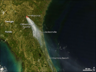
The images above are from NASA's earth obeservatory on April 17 and April 19 respectively. They show the smoke plume from the fires.

Below is the current fire danger rating map for the state.

Mac McCormick, KF4LMT

Severe Drought Conditions Develop Across Georgia

This article is from the University of Georgia College of Agricultural and Environmental Sciences website

Severe drought conditions develop across Georgia

Northwest, southeast Georgia getting even drier.

Severe drought conditions have developed across northwest and southeast Georgia. The remainder of the state is still in moderate to mild drought, except the lower Flint River Valley, which is abnormally dry for the middle of April.

By David Stooksbury
University of Georgia

Athens, Ga. -- Severe drought conditions have developed across northwest and southeast Georgia. The remainder of the state is still in moderate to mild drought, except the lower Flint River Valley, which is abnormally dry for the middle of April.

In northwest Georgia, Polk, Floyd, Chattooga, Walker, Dade and Catoosa counties are in severe drought.

In southeast Georgia, severe drought conditions are east and south of a line through Thomas, Brooks, Cook, Berrien, Coffee, Jeff Davis, Toombs, Tattnall, Evans, Bryan and Chatham counties.

Moderate drought conditions are found north and west of a line through Haralson, Paulding, Bartow, Gordon, Pickens, Gilmer, Union and Towns counties.

Grady, Colquitt, Tift, Irwin, Ben Hill, Telfair, Wheeler, Montgomery, Treutlen, Emanuel, Candler, Bulloch and Effingham counties are also in a moderate drought. The rest of the state is in mild drought, except the lower Flint River Valley, which is abnormally dry.

In the regions with severe drought, the soil moisture and stream flow levels are at or below the 5th percentile. That means that soil moisture and stream flow levels are greater than the current values in 95 out of 100 years.

In the regions with moderate drought, soil moisture and stream flow levels are between the 5th and 10th percentiles, so these levels are greater than the current values in 90 of 100 years.

Deep deficits

Rainfall deficits for Jan. 1 through April 16 include Athens at 4.02 inches, Augusta 4.27, Columbus 5.04, Savannah 5.67, Macon 6.03, Plains 6.44, Brunswick 6.87, Tiger 7.54, Atlanta 7.98, Alma 8.42, Tifton 9.02, Blairsville 9.64 and LaFayette 11.27.


During the past week, portions of Georgia received beneficial rain. Among the places getting more than 1 inch of rain over the past seven days are Pine Mountain at 1.02 inches, Alpharetta 1.10, Atlanta 1.14, Arlington 1.21, Athens 1.37, LaFayette 1.47, Macon 1.67, Newton 1.84, Albany 2.03, Jeffersonville 2.33, Augusta 2.44, Columbus 2.58, Elberton 2.80, Dublin 3.04 and Cordele 3.37.

The U.S. Geological Survey reports daily record-low flows for April 16 in northwest Georgia on the Coosawattee River near Pine Chapel at Carters and near Ellijay and on Cedar Creek near Cedartown.

In southeast and south-central Georgia, daily record-low flows were reported on the Ocmulgee River at Lumber City, the Altamaha at Doctortown and near Baxley, the Ogeechee near Eden, the Ochlockonee near Thomasville, the Alapaha near Alapaha and at Statenville, the Suwannee at Fargo, the Little Satilla near Offerman and the Satilla near Waycross and at Atkinson.

Over the past two weeks, Lake Lanier's water level has remained nearly constant and is 2.5 feet below full summer pool. Hartwell and Clarks Hill are 1.8 and 1.1 feet below full summer pool, respectively.

Levels are near the desired level for middle April at Allatoona and Carters. West Point and Walter F. George have levels above the guidance for middle April.

Groundwater levels have shown some improvement with recent rains across southwest Georgia. Levels across south-central and southeast Georgia continue to drop.

Little relief

Little if any relief from the drought is anticipated in the foreseeable future.

The entire state remains under the level-1 outdoor water-use schedule. Outdoor watering is allowed only from midnight to 10 a.m. and 4 p.m. to midnight on Sundays, Tuesdays and Thursdays at odd-number street addresses and on Mondays, Wednesdays and Saturdays at even-number addresses. It's banned all day on Fridays.

Local water authorities may further restrict outdoor watering.

The state drought response committee will assess the dry weather and discuss outdoor water use schedules April 18 at 1 p.m. The group will meet in Suite 1252 East Tower in the Floyd State Office Towers at 2 Martin Luther King Jr. Drive in Atlanta.

The committee includes representatives of several state agencies, the U.S. Army Corps of Engineers, U.S. Geologic Survey, U.S. Fish and Wildlife Service, a regional development center, the agricultural industry and the business community.

Updated weather information is at www.georgiaweather.net. This University of Georgia network has 71 automated weather stations statewide.

Updated drought information is at www.georgiadrought.org. The site includes updated climatic conditions and information on how to deal with the drought.

(David Stooksbury is the state climatologist and a professor engineering and atmospheric sciences in the University of Georgia College of Agricultural and Environmental Sciences.)

Firefighting Coalition Battles South Georgia Fires

The following news release is from the Georgia Forestry Commission website. Based on reports from radio hobbyists on several groups, including the ScanSavannah group, firefighters from Bulloch, Candler, Effingham, and Chatham Counties have responded to the Waycross area to assist in firefighting efforts. Additionally, Georgia Army National Guard CH-47Ds from Hunter AAF have been working the fire as well.

FIREFIGHTING COALITION BATTLES SOUTH GEORGIA WILDFIRES

More than 200 firefighting professionals from the Georgia Forestry Commission (GFC) and other emergency management agencies are battling fires in south Georgia that have blackened over 10,000 acres and destroyed several homes.

“This one will go into the history books of wildland fires in Georgia,” said Frank Sorrells, GFC Waycross District Ranger, of the Ware County-Sweat Farm Road fire. “We’re pulling equipment and personnel in from all over Georgia and more are on standby to put out this dangerous fire.” The fire has scorched an area measuring 11 miles long and one mile wide and is spreading into the Okefenokee Swamp. An estimated 1,000 homes in the southern part of Waycross were evacuated Tuesday afternoon. The Okefenokee Swamp Park has also been evacuated.

The Georgia Forestry Commission’s Incident Management Team is managing this fire and several others in southeast Georgia. Fires have burned some 3,000 acres in Brantley and Wayne counties. “Conditions have been extremely dry,” said Sorrells, “and the humidity remains very low. Winds are out of the northwest at about eight to ten miles an hour, so that’s pushing the fire further south.” Smoke from the wildfires is affecting areas as far away as Jacksonville and St. Augustine, Florida.

Sorrells is urging residents close to these fires to stay tuned to news reports and refrain from outdoor burning until further notice.

21 April 2007

AB4BC's Amateur Radio Blog

If you are interested in homebrew equipment and antique radio construction, check out Brian Cave, AB4BC's Yahoo site and blog at http://360.yahoo.com:80/ab4bc_hamradio

Brian is currently working on a linear amplifier project and you can keep up with his progress on the blog at the above URL. He's keeping great notes on where to find the parts, especially some of the harder to find ones.

Mac McCormick, KF4LMT
kf4lmt@comcast.com

17 April 2007

No Weekly MilCom Recap, Limited Activity This Week

Due to my work schedule, there will be no weekly MilCom recap from last week and there will probably be limited activity on the blog until Friday or Saturday of this week. I just don't have time to put together the recap. Other posts will be depend on how much free time I have. Hopefully I'll get back to normal next week.

Thanks for reading

Mac McCormick, KF4LMT
kf4lmt@comcast.net

Effingham County Forest Fires


The map at left is the Georgia Forestry Fire Danger Rating Map for April 16, 2007. To put it simply, green is good and purple is bad. It is obvious that the Savannah area is in a bad way. You can check the fire danger rating throughout the state with this map; it is updated daily here.


Firefighters and Forestry Workers in Effingham County fought three different fires today; one in the area of the County Landfill, one north of Springfield, and one in the Hodgeville Road area. Based on monitoring, they were problematic due to the very high winds in the area today. Similar to the fires of last week, a Georgia Forestry aircraft was fire spotting for the ground crews and personnel from other departments were called to assist. As near as I could tell, the Pooler and Bloomingdale Fire Departments sent apparatus and personnel for the Landfill area fire and Newington may have sent some for the fire north of Springfield.


I didn't have the chance to monitor these fires as in depth as I did the one in Chatham County last week, but this fire was an opportunity to discover and identify some new talkgroups on the Chatham-Effingham Trunked Repeater System.


Conventional Frequencies
155.355 - Effingham Fire/EMS Dispatch
155.115 - Effingham North Fire Repeater
159.390 - Georgia Forestry Mobile-to-Mobile


Chatham-Effingham TRS
17200 - Effingham Fire/Rescue Admin 2
26456 - Effingham Fire Dispatch
26488 - Effingham EMS Dispatch
25104 - Effingham Fire/Rescue Fireground 1
25136 - Effingham Fire/Rescue Fireground 2
25168 - Effingham Fire/Rescue Fireground 3
25200 - Effingham Fire/Rescue Admin 1
25904 - Rincon FD
26064 - Guyton FD
26512 - Effingham County Incident 1
26544 - Effingham County Incident 2
26576 - Effingham County Incident 3


Mac McCormick, KF4LMT

13 April 2007

Oglethorpe Speedway Project: Report 1

After several years of not finding the opportunity to catch a race at Oglethorpe Speedway, I finally made it to a race. It was good to see a race live, taking in the smells of rubber, gasoline, and oil and inhaling the swirling clay dust that gets all over everything in sight. I of course took a radio along (2 actually) as well as the old Sony digital camera. I really wanted to work on my Oglethorpe Speedway monitoring project, so I got there early and started searching using a PRO-92, a stubby antenna, and a good set of headphones.

On this first trip to the track, I concentrated mostly on track frequencies. I found one frequency in use by the track officials, track workers, wreckers, and fire/ems units. If you recall my post about this project in early March, I mentioned a "Raceceiver" system that was supposed to be in use at Oglethorpe; I found it as well. The "Raceceiver" is used by the track officials to talk to the cars during the races. Some of the Pure Stock cars and all of the Street Stock and Late Model cars utilize the system.

461.500 - DCS 026 - Oglethorpe Speedway Park Officials
457.250 - CSQ - Raceceiver

I did do some searching late in the evening and found some frequencies in use by the teams , finding some for the Pure Stock, Street Stock, and Late Model classes. Unfortunately I wasn't able to determine a team on most of the finds.


451.9375 - Pure Stock, unknown team
464.7875 - Pure Stock, unknown team


461.1250 - Street Stock, unknown team
461.7125 - Street Stock, unknown team
463.7125 - Street Stock, Car 11


461.0125 - DCS 565 - Late Model
462.5750 - unknown


I only used one radio at a time tonight, but the die-hard radio hobbyist would best be served at the track by two radios. The first radio would be used to scan the track officials and the "raceceiver" system. The second radio would be used to scan team frequencies and/or search for new frequencies. 461.500 is definitely one you want to keep an ear on as much as possible because the officials' communications tell you exactly what is going on.


Mac McCormick, KF4LMT

12 April 2007

New Hangar For More Aircraft at NAS Jacksonville

From the Jacksonville Times-Union:

http://www.jacksonville.com/tu-online/stories/041207/met_9191226.shtml

NAS Jacksonville is building a 277,000 square foot hangar to house more P-3s and C-130s that they base will gaining as a result of BRAC.

Mac McCormick, KF4LMT
kf4lmt@comcast.net

GA Army National Guard CH-47s Move a Cannon at Fort Pulaski

http://savannahnow.com/node/260606

I came across this article in the Savannah Morning News today. CH-47s from Hunter AAF helped move a cannon at the Fort Pulaski National Monument yesterday. In this article, it names the unit as Bravo Company, 169 Aviation Regiment. Apparently I missed a unit name change somewhere along the line, so I did a bit of research and found that have indeed changed name from F-131 AVN to B-169 AVN. Aircraft, Personnel, Callsigns, and Frequencies seem to have remained the same.

Mac McCormick, KF4LMT
kf4lmt@comcast.net

Forest Fires in Chatham and Effingham Counties

Dry conditions finally caught up with us today. Throughout the afternoon and this evening, Georgia Forestry and local fire departments fought forest fires in Chatham County near I-16 and the Pooler Parkway and in Effingham County near Guyton. Air operations augmented the firefighters and bulldozers on the ground at both fires. Based on radio traffic between the Georgia Forestry aircraft, there were also fires in Long County and Bulloch County.

Note the presence of Eastern District (Sunbury) fire units working the fire in Chatham County. Additional units from other counties were also on standby for mutual aid as well.

Chatham Forest Fire
Conventional Frequencies

159.225 - Georgia Forestry District 10 Repeater

159.390 - Georgia Forestry Mobile-to-Mobile
-Aircraft 0Z/38H, fire spotting
-CHOPPER 3, water drops
-013
-POOLER COMMAND CENTER
-BRYAN ##, CHATHAM ##, EMMANUEL ##, JENKINS ##, LONG ##, TATTNALL ##

168.775 - Ch. 9 (US Forestry 1)
-Aircraft 0Z wkg BRYAN ##

169.900 - Ch. 10 (US Forestry 3)
-Aircraft 0Z wkg CHATHAM ##

123.400 - Georgia Forestry Air-to-Air
-Aircraft 0Z
-CHOPPER 3
-CHOPPER 7 (sent to Effingham Fire)
-N241JH (Chatham Co.)
-Air Tractor N60057 (Chatham Co.)

Chatham-Effingham TRS
TG 37072 - Fire Common, Primary Working Channel
-COMMAND
-ENTRY CONTROL
-STAGING
-Savannah Fire
-Garden City FD 2#, 12##
-Port Wentworth FD 4#, 14##
-Thunderbolt FD 5#, 5##
-Pooler FD 6#, 16##
-Bloomingdale FD 8#, 18##
-Southside FD
-CEMA 3, CEMA 4
-Effingham FD 54
-Eastern District (Sunbury) 2#

TG 36880 - Savannah Fire Dispatch
TG 36912 - Savannah Fire Admin
TG 3568 - Chatham Metro Fire Dispatch
TG 4592 - Port Wentworth FD
TG 4752 - Thunderbolt FD
TG 5040 - Garden City FD
TG 5424 - Pooler FD


Effingham Forest Fire
Conventional Frequencies
159.225 - Georgia Forestry District 10 Repeater

159.285 - SE Compact
-Aircraft 0X, fire spotting
-CHOPPER 7, water drops
-BULLOCH ##
-EFFINGHAM ##

155.355 - Effingham Fire/EMS Dispatch
155.115 - North Effingham Fire Repeater

Chatham-Effingham TRS
TG 25200 - Effingham Fire Admin 1
TG 25104 - Effingham Fire Fireground 1


Mac McCormick, KF4LMT
kf4lmt@comcast.net

11 April 2007

Chatham-Effingham TRS Talkgroup Updates

Over the last week, I've been able to confirm two more Effingham County talkgroups: Effingham Fire/Rescue Fireground 2 and Guyton FD.

TG 25136 - Effingham Fire/Rescue Fireground 2
TG 26064 - Guyton FD

With 25136 confirmed as Fireground 2 and 25200 as Admin 1, I would feel very safe in considering 25168 as Fireground 3, even though I haven't heard it in use yet. As far as city FDs in Effingham goes, with Rincon on 25904 and Guyton on 26064, Springfield is the only city FD that a city channel hasn't been found for yet.

Mac McCormick, KF4LMT
kf4lmt@comcast.net

Morse Code v. Text Messaging: What gets through quicker?

This video appeared in my inbox yesterday. I thought it was pretty interesting.


Just because a technology is old, that doesn't mean that it has outlived it's usefulness. Even though I don't have an interest in amateur radio operations on HF and haven't yet learned CW, I refuse to denigrate it as an operating mode. Every mode of operation has it's place.

Mac McCormick, KF4LMT
kf4lmt@comcast.net

Monitoring the Military, Part 4: Unit Frequencies

This article originally appeared in the April 2007 issue of Key Klix, the newsletter of the Amateur Radio Club of Savannah. It is the fourth in a series of articles on monitoring military communications in the Savannah area.

An article in Key Klix is definitely not enough space to list frequencies for military units that can be heard from the Savannah area. With this month’s article, I’ll list those that can be easily heard in Savannah on a daily basis. If you are interested in a more exhaustive list, drop me an email and I’ll send it along.

Hunter AAF
The 3rd Aviation Brigade of the 3rd Infantry Division is based at Hunter AAF. The brigade is broken down into 4 battalions of helicopters. 1-3 Aviation flies the AH-64D Apache Longbow. 2-3 Aviation flies UH-60L and UH-60A Blackhawks and the CH-47D Chinook. 3-3 Aviation flies the AH-64D Apache Longbow. 4-3 Aviation flies the UH-60L Blackhawk. F-131 Aviation is a Georgia Army National Guard unit that flies the CH-47D Chinook. Each unit has an operations office, which has an assigned frequency. The aircraft use that “Ops” frequency to communicate maintenance information, mission information, or anything else back to the unit. Additionally, the United States Coast Guard’s Air Station Savannah is located at Hunter AAF, which uses a UHF frequency to communicate between their HH-65C Dolphins and the Air Station, “Savannah Air.”

45.900 - 1-3 AVN OPS
49.800 - 2-3 AVN OPS
32.350 - 3-3 AVN OPS
49.900 - 4-3 AVN OPS
38.150 - F-131 AVN OPS
139.400 - F-131 AVN OPS
345.000 - USCG Air Station

Savannah International Airport
Savannah International Airport is home to the 165th Airlift Wing of the Georgia Air National Guard. The 165th AW flies the C-130H Hercules. They utilize a Command Post (CP) frequency, which is used somewhat like the Ops frequencies for the Army units at Hunter AAF. They also use an Air-to-Air frequency for communication between aircraft.

225.050 - 165 AW Air-to-Air
225.750 - 165 AW CP

Marine Corps Air Station Beaufort
Marine Corps Air Station (MCAS) Beaufort is home to seven squadrons of F/A-18 Hornets. Two of the squadrons fly the A+ model, three fly the C model, and two fly the D model two-seat version. 6 of the squadrons are Marine Corps squadrons (identified by the VMFA designators) and one is a US Navy squadron (identified by the VFA designator). The Marine and Navy units use terminology a bit different from the Army and Air Force/Air National Guard. Instead of an Ops or Command Post frequency, the Marine Corps and Navy squadrons utilize Base frequencies on which they call their squadron’s “Base” to pass information to the unit. Instead of an Air-to-Air frequency, they use “Tac” frequencies, which are used for both air-to-air and air-to-ground use.

361.800 - VMFA-115 BASE
339.500 - VMFA-115 TAC 1
320.200 - VMFA-115 TAC 2

253.100 - VMFA-122 BASE
283.400 - VMFA-122 TAC 1
354.325 - VMFA-122 TAC 2

305.800 - VMFA-224 BASE
250.300 - VMFA-224 TAC 1
258.900 - VMFA-224 TAC 2
336.225 - VMFA-224 TAC 3

313.800 - VMFA-251 BASE
290.000 - VMFA-251 TAC 1
327.475 - VMFA-251 TAC 2

228.200 - VMFA-312 BASE
301.950 - VMFA-312 TAC 1
320.300 - VMFA-312 TAC 2

310.200 - VMFA-533 BASE
289.275 - VMFA-533 TAC 1
299.300 - VMFA-533 TAC 2
348.825 - VMFA-533 TAC 3

354.400 - VFA-86 BASE
308.925 - VFA-86 TAC 1
363.825 - VFA086 TAC 2

Jacksonville International Airport
Jacksonville International Airport is home the 125th Fighter Wing of the Florida Air National Guard. The 125th FW is equipped with the F-15A Eagle. Even though they are based in Florida, they are daily visitors to the airspace offshore from Georgia and are easily heard in Savannah. The 125th FW utilizes a Command Post/Maintenance (CP/MX) frequency, a Supervisor of Flying (SOF) frequency, and 4 Auxiliary (Aux) frequencies which are air-to-air frequencies.

251.250 - FANG MX/CP
273.900 - FANG SOF
234.800 - FANG AUX 6
253.700 - FANG AUX 7
314.200 - FANG AUX 8
343.000 - FANG AUX 9

Mac McCormick, KF4LMT
kf4lmt@comcast.net

Monitoring the Military, Part 3: Operating Areas and Ranges

This article originally appeared in the March 2007 issue of Key Klix, the newsletter of the Amateur Radio Club of Savannah. It is the third in a series of articles on monitoring military communications in the Savannah area.

Some of the destinations for military aircraft while they are on air traffic control frequencies are Military Operating Areas (MOAs), Special Use Areas (SUAs) and Ranges. There are several MOAs and Ranges in the Savanah area and a group of SUAs off of the Georgia coast. Basically, these areas are where the flight crews and aircraft conduct training operations for air-to-air combat and air-to-ground combat.

SEALORD and the offshore SUAs
SEALORD is the radio callsign for the United States Navy Fleet Area Control and Surveillance Facility (FACSFAC) at NAS Jacksonville, FL. SEALORD controls the SUAs off of the east coast of GA, FL, and SC. These SUAs are made up of a group of air-to-air, air-to-surface, surface and subsurface ranges. While the surface activity is usually well out of VHF/UHF range, the aerial activity is for the most part well within range for listeners in Savannah. Among the aircraft using the airspace are F/A-18 Hornets, F-16 Falcons, F-15 Eagles, P-3 Orions, S-3 Vikings, E-8 JSTARS, and E-3 AWACS.

SEALORD uses a collection of primary, secondary, and discrete frequencies to control their airspace. Aircraft checking in and out of the airspace with SEALORD use the primary and secondary frequencies. Once they are checked into, or “established” in the airspace, they will be switched to a discrete, or “working” frequency for their training operations. Some of the more frequently used SEALORD frequencies are:

284.500 - UHF Primary North Fixed Wing Frequency
313.700 - UHF Secondary North Fixed Wing Frequency
120.950 - VHF Primary North
267.500 - UHF Primary South Fixed Wing Frequency
133.950 - VHF Primary South

349.800 - Discrete
376.900 - Discrete
385.300 - Discrete

301.000 - TACTS Range Discrete
350.000 - TACTS Range Discrete

Note: The TACTS Ranges are instrumented air-to-air combat ranges.

Air Traffic Control frequencies that are used to transition to and from the SUAs are 120.400/380.025 and 125.300/387.100 with Savannah Approach and Departure as well as 282.200, 277.400 and 363.200 with Jacksonville Center.

Fort Stewart Ranges
MARNE RADIO controls the airspace over and around Fort Stewart. Aircraft entering or leaving Fort Stewart’s airspace check in and out with MARNE RADIO. Most of the Fort Stewart ranges are used for surface-to-surface activity, but there is air-to-ground activity from the helicopters at Hunter AAF and fixed wing attack aircraft. Transports such as C-130s and C-17s also practice air drops at Fort Stewart’s drop zones. If they will be using a range, they can be switched to a range control frequency. If the aircraft is doing paradrops of personnel or cargo, they may be switched to a drop zone frequency. Most helicopter activity quickly becomes out of range for listeners in Savannah due to the low altitude the helicopters fly at. Fixed wing aviation occasionally uses the airspace, however, and they can usually be heard in Savannah.

127.350 - Marne Radio
279.625 - Marne Radio

48.500 - Range Control
234.250 - Range Control
280.800 - Range Control
238.250 - Drop Zone

Air Traffic Control frequencies that are used to transition to and from the Fort Stewart Ranges and Marne Radio are 120.400/380.025 with Savannah Approach and Departure as well as 282.200 and 277.400 with Jacksonville Center.

The Coastal MOAs and Townsend Range
The Coastal MOAs are comprised of airspace above and around Townsend Range near Townsend, GA in McIntosh County. The Coastal MOAs and Townsend Range are mostly used for air-to-ground training, but they can also be used for air-to-air training. Weapons can only be dropped or fired in the range airspace. Operated by the Georgia Air National Guard, aircraft from all of the military services and from all over the southeast and other parts of the country use Townsend Range.

119.225 - Range Control
228.400 - Range Control
252.900 - Range Control

Air Traffic Control frequencies that are used to transition to and from the Coastal MOAs and Townsend Range are 120.400/380.025 with Savannah Approach and Departure as well as 282.200 and 277.400 with Jacksonville Center.

Next month, I’ll move on to discuss callsigns and frequencies used by some of the squadrons in the Savannah area. By combining the air traffic control or range traffic with interplane communications, you can get a more complete idea of what the aircraft are doing and have a more enjoyable monitoring experience.

Mac McCormick, KF4LMT
kf4lmt@comcast.net

07 April 2007

Military Monitoring Recap; 2-8 April 2007

Amazingly, most of the last week's monitoring was done while mobile. I managed to monitor AWACS activity from BANDSAW, CHALICE, DARKSTAR, DRAGNET, and GOLIATH that occurred off of the coast of Georgia and South Carolina while mobile in central Effingham County. As I mentioned in an earlier post this week, the Coastal Georgia and South Carolina area saw heavy AWACS activity. Every day between 1330 and 1500 there was at least one AWACS working the area. On Monday, when I was around a radio almost all day, they activity lasted all throughout the day.

Frequencies
Hunter AAF
133.550 - Tower
279.575 - Tower
126.200 - Base Ops
32.350 - SHARK OPS (3-3 AVN)
82.100 - SUNNY OPS (224 MI Bn)
345.000 - USCG Air Station Savannah
406.1625 - Tower/Base Ops
406.7625 - POL
415.1625 - Trans Alert

Savannah IAP
119.100 - Tower
257.800 - Tower
225.750 - 165 AW Command Post
165.0125 - 165 AW Maintenance

Fort Stewart
127.350 - Marne Radio
279.625 - Marne Radio

MCAS Beaufort
301.200 - Approach/Departure
251.700 - Approach/Departure
118.450 - Approach/Departure
340.200 - Tower
119.050 - Tower
361.800 - VMFA-115 Base
339.500 - VMFA-115 Tac 1
320.200 - VMFA-115 Tac 2
253.100 - VMFA-122 Base
283.400 - VMFA-122 Tac 1
354.325 - VMFA-122 Tac 2
228.200 - VMFA-312 Base
301.950 - VMFA-312 Tac 1
320.300 - VMFA-312 Tac 2
310.200 - VMFA(AW)-533 Base
348.825 - VMFA(AW)-533 Tac 3

Shaw AFB
311.200 - SHOOTER OPS (55th Fighter Squadron)
141.900 - 55 FS V8
139.750 - 55 FS V10
273.700 - GAMBLER OPS (77th Fighter Squadron)
143.800 - 77 FS V8
141.750 - 77 FS V9
320.525 - SNAKE OPS (79th Fighter Squadron)
141.600 - 79 FS V9
141.775 - 79 FS V10
138.200 - 79 FS air-to-air

McEntire ANGB
298.300 - SWAMP FOX OPS (169th Fighter Wing)
125.125 - 169 FW V1
141.925 - 169 FW V18
141.825 - 169 FW V19

Jacksonville IAP
251.250 - 125th Fighter Wing Command Post/Maintenance
234.800 - 125 FW Aux 6
253.700 - 125 FW Aux 7
314.200 -125 FW Aux 8

Robins AFB
293.525 - PEACHTREE OPS (116th Air Control Wing)

Ranges/MOAs
228.400 - Townsend Range Control
252.900 - Townsend Range Control
354.300 - Poinsett Range, BEEFEATER ECM Range
269.000 - Gamecock D MOA

SEALORD
120.950 - North Primary VHF
284.500 - North Primary UHF
133.950 - South Primary VHF
267.500 - South Primary UHF
376.900 - W-157 Discrete
385.300 - W-157 Discrete
301.000 - South TACTS Range
350.000 - South TACTS Range

DOUBLESHOT
279.725 - Doubleshot Primary
127.725 - Doubleshot Primary
258.400 - W-161/177 Discrete
381.350 - W-161/177 Discrete

NORAD/AWACS
364.200 - AICC
264.500 - NORAD Discrete? (DARKSTAR calling NORTHERN LIGHTS)
293.600 - NORAD Discrete
388.950 - NORAD Discrete
254.475 - AWACS Discrete
317.950 - AWACS Discrete
141.650 - AWACS Assigned fight common

Miscellaneous
310.200 - NAS Jacksonville Base Ops
344.600 - Charleston AFB PMSV
349.400 - PALMETTO OPS (Charleston AFB CP)


ARTCC/Air Traffic Control
277.400 - Jax Center, Brunswick Low
282.200 - Jax Center, Jekyll Low
285.650 - Jax Center, Statesboro High
290.400 - Jax Center, Waycross Low
307.250 - Jax Center, St. Augustine
322.500 - Jax Center, Savannah Low
351.700 - Jax Center, Summerville High
363.200 - Jax Center, Allendale Low

273.600 - Atlanta Center, Macon
323.000 - Atlanta Center, Macon

255.400 - Macon Radio FSS

US Coast Guard
156.800 - Marine VHF Ch. 16
157.050 - Marine VHF Ch. 21 (Sector Charelston Operating Channel)
157.100 - Marine VHF Ch. 22
157.075 - Marine VHF Ch. 81


Callsigns
Hunter AAF
ARMY - Miscellaneous US Army
ASSAULT - UH-60L, 4-3 AVN
SUNNY - RC-12N, 224 MI Bn)COAST GUARD - Miscellaneous Coast Guard
JENA - FBI
HUSTLER - CH-53E, HMH-772
NAVY LL ## - P-3C, VP-30
NAVY LN ## - P-3C, VP-45

Savannah IAP
DAWG - C-310H, 165th Airlift Wing

MCAS Beaufort
BLADE - F/A-18A+, VMFA-115
NIKEL - F/A-18A+, VMFA-122
CHECK - F/A-18C, VMFA-312
HAWK - F/A-18, VMFA(AW)-533

Shaw AFB
MEAT - F-16CJ, 55th Fighter Squadron
PISTOL - F-16CJ, 55 FS
RAZOR - F-16CJ, 55 FS
BOOKIE - F-16CJ, 77th Fighter Squadron
DECK - F-16CJ, 77 FS
LOAD - F-16CJ, 77 FS
MUSTANG - F-16CJ, 77 FS
BEAST - F-16CJ, 79th Fighter Squadron
DEADLY - F-16CJ, 79 FS
HOOTER - F-16CJ, 79 FS
PROWL - F-16CJ, 79 FS
SPITFIRE - F-16CJ, 79 FS

McEntire ANGB
VIPER - F-16CJ, 169th Fighter Wing
DEMON - F-16CJ, 169 FW
HEAT - F-16CJ, 169 FW

Jacksonville IAP
FANG - F-15A, 125th Fighter Wing
SNAKE - F-15A, 125 FW
RATTLER - F-15A, 125 FW
COIL - F-15A, 125 FW

Robins AFB
PEACH - E-8C, 116 Air Control Wing

Miscellaneous
BANDSAW - E-3, 964 ACCS backend
BACKBURNER - unknown ground station
CHALICE - E-3, 963 ACCS backend
CHROME(?) - alias for CHALICE?
DARKSTAR - E-3, 965 ACCS backend
DEUCE - KC-10, 305 ARW
DRAGNET - E-3, 966 ACCS backend
GOLIATH - E-3, 966 ACCS backend
KING - USAF HC-130
REACH - Miscellaneous Airlift
SENTRY - E-3 front end
SODA - KC-135, 151 ARS
VIDAR - S-3B, VS-22


Mac McCormick, KF4LMT
kf4lmt@comcast.net

05 April 2007

Exercise "Smokin' Hole?"

For the third day in a row, there was AWACS activity in the southeast. Each day, the activity has (for what I've been able to monitor) mostly been in the W-161/177 area controlled by DOUBLESHOT. Based on some traffic I heard today, all of this AWACS activity could be part of an exercise. On 364.200 (AICC), a radio operator on BANDSAW (E-3. 964 ACCS) called BACKBURNER (unknown) with an inquiry about "Exercise Smokin' Hole" (it could be Smoking Hole, but the op didn't pronounce the G).

Mac McCormick, KF4LMT
kf4lmt@comcast.net

02 April 2007

Dry Conditions = Heavy Forestry Activity

Conditions in the Savannah area have been extremely dry lately, leading to higher fire dangers as indicated on the Georgia Forestry Commission's Fire Danger Rating map: http://weather.gfc.state.ga.us/Maps/fd.gif

As a result, both Georgia Forestry and South Carolina Forestry have been very busy spotting fires with aircraft and fighting fires. Georgia Forestry District 10 and South Carolina's Coastal Base were very active today with both aircraft and ground units:

151.370 - GFC District 10 Admin
159.390 - GFC Mobile-to-Mobile
159.225 - GFC District 10 Repeater
159.285 - Southeast Compact

159.315 - SCFC Coastal Base
159.450 - SCFC Beaufort Repeater

Fort Stewart Forestry has also been busy fighting fires. They fought a large one at the end of last week using talkgroup 2480 of the Fort Stewart TRS for ground operations and 163.5625 to work with a helicopter spotting the fires.

This morning, Garden City Fire, Pooler Fire, Port Wentworth Fire, and Georgia Forestry worked a series of fires alongside railroad tracks in the Chatham City and Wheathill areas. They used Fire Common (TG 37072 on the Chatham-Effingham TRS) as a working channel along with some use of their respective department talkgroups.


Mac McCormick, KF4LMT
kf4lmt@comcast.net

AWACS, AWACS, AWACS

Today reminds me of the days of OAKGROVE when the FL/GA/SC coast saw almost daily AWACS activity and there was an active NORAD radio presence. There were three different E-3 AWACS in the GA/SC area today: DARKSTAR (E-3, 965 ACCS), DRAGNET (E-3, 966 ACCS), and CHALICE (E-3, 963 ACCS). They worked with fighters in the W-161/177 areas, W-157 areas, and in the Gamecock MOA. DRAGNET and CHALICE also worked with the BEEFEATER electronic warfare range.

127.725/279.725 - DOUBLESHOT (W-161/177)
258.400 - DOUBLESHOT Discrete
381.350 - DOUBLESHOT Discrete

284.500 - SEALORD (W-157)
301.000 - S. TACTS Range Discrete
350.000 - S. TACTS Range Discrete

269.000 - Gamecock MOA

354.300 - BEEFEATER ECM Range


Mac McCormick, KF4LMT
kf4lmt@comcast.net

B-2 Stealth Bombers in Coastal Georgia

This morning brought a rare treat for MilCom hobbyists in the southeast, a flight of 3 B-2 bombers working Townsend Range in coastal Georgia. FURY 11-13 (B-2, 509 BW) used 228.400 and 252.900 with Range Control and used 388.850 for air-to-air. The B-2s were working relatively low level; I lost signals on them several times as they went low-level (I did hear altitudes as low as 3,000 ft mentioned). This put them lower than the F-16s that worked the range earlier; I never lost signals on them!

Mac McCormick, KF4LMT
kf4lmt@comcast.net

VMFA(AW)-332 Temporary Deactivation

The Beaufort Gazette ran this article about the deactivation ceremony for VMFA(AW)-332. They list the scheduled reactivation date with the JSF as 2011.

http://www.beaufortgazette.com/local_news/story/6440718p-5738620c.html


WTOC in Savannah also had a story on VMFA(AW)-332 last week, they too give 2011 as a date for reactivation with the JSF.

http://www.wtoc.com/Global/story.asp?S=6306673


Unfortunately I was working a 10 hour shift on Friday and missed the last flight of a Moonlighters F/A-18D. I would have loved to have been able to log that one...


Mac McCormick, KF4LMT
kf4lmt@comcast.net

01 April 2007

Shaw Air Force Base VHF Trunked Repeater System

During my trip to Florence and Darlington yesterday, I was able to help identify the Shaw AFB TRS. A few months ago, I was asked to check out some frequencies that were known to be a trunked system in South Carolina, probably Shaw AFB or McEntire ANGB. At that time I was unable to determine much while in Columbia because of band conditions. VHF was wide open that morning and it was almost impossible to pick local transmissions from distant transmissions. During yesterday's trip conditions were normal, so I was able to nail down the location as Shaw AFB. Once I figured out the settings for the system, I was able to monitor it with the BC-796. Stations using the callsign SHAW and references to the 79th Fighter Squadron confirmed it as the Shaw AFB TRS.

SETTINGS & FREQUENCIES 9600 Baud Motorola
Base Freq: 162.0000
Step: 12.5
Offset: 380

163.4625 - Control Channel (9600 baud)
165.0125 - Digital Voice
165.1875 - Digital Voice
165.2250 - Digital Voice
165.4125 - Digital Voice
166.0000 - Digital Voice
166.2250 - Digital Voice

TALKGROUPS
19 - Fire?
20 - unknown
21 - unknown
25 - Police?
28 - Squadron talkgroup?
34 - Tower/Ground Control?
42 - POL?

Much work still needs to be done on sorting out this system. The talkgroup info above was accquired from less than one day (a Saturday no less) of monitoring while passing the area on I-95. If you are in the area, or are visiting the area, do some monitoring on this system. Please pass on your information to me or to Larry Van Horn at the Monitoring Times MilCom Monitoring Blog.


Mac McCormick, KF4LMT
kf4lmt@comcast.net